

Typhoon Chan-hom Forecast to Enter the East Sea on 12: How Far Could Its Impact Reach South Korea After Crossing Japan?
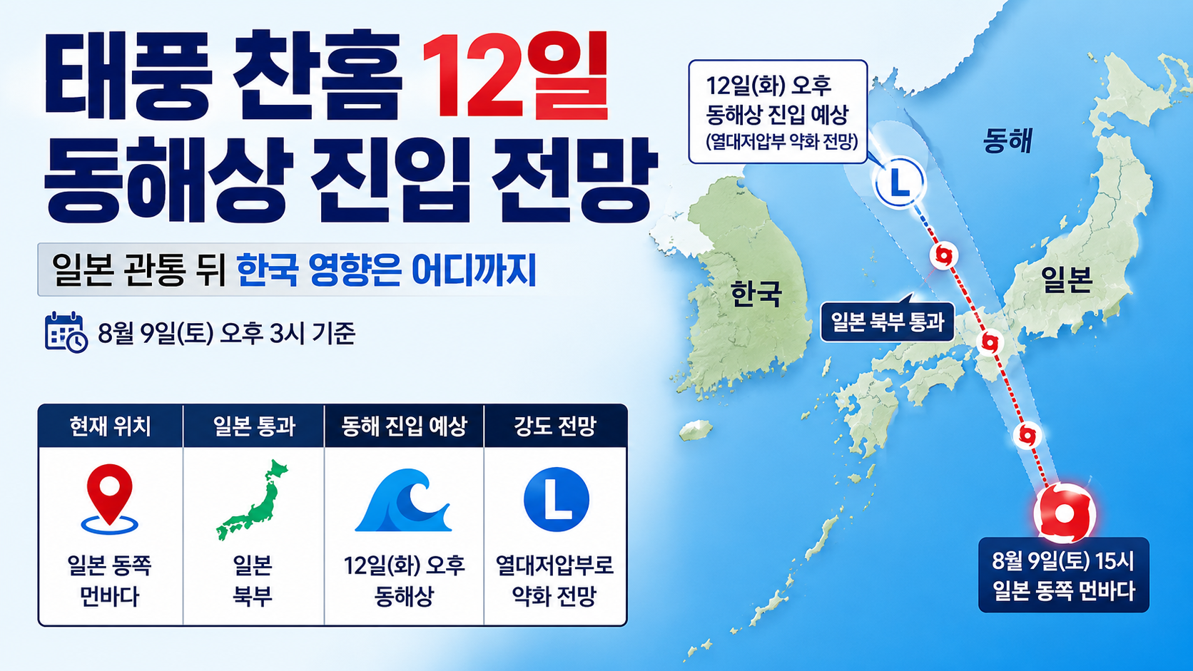
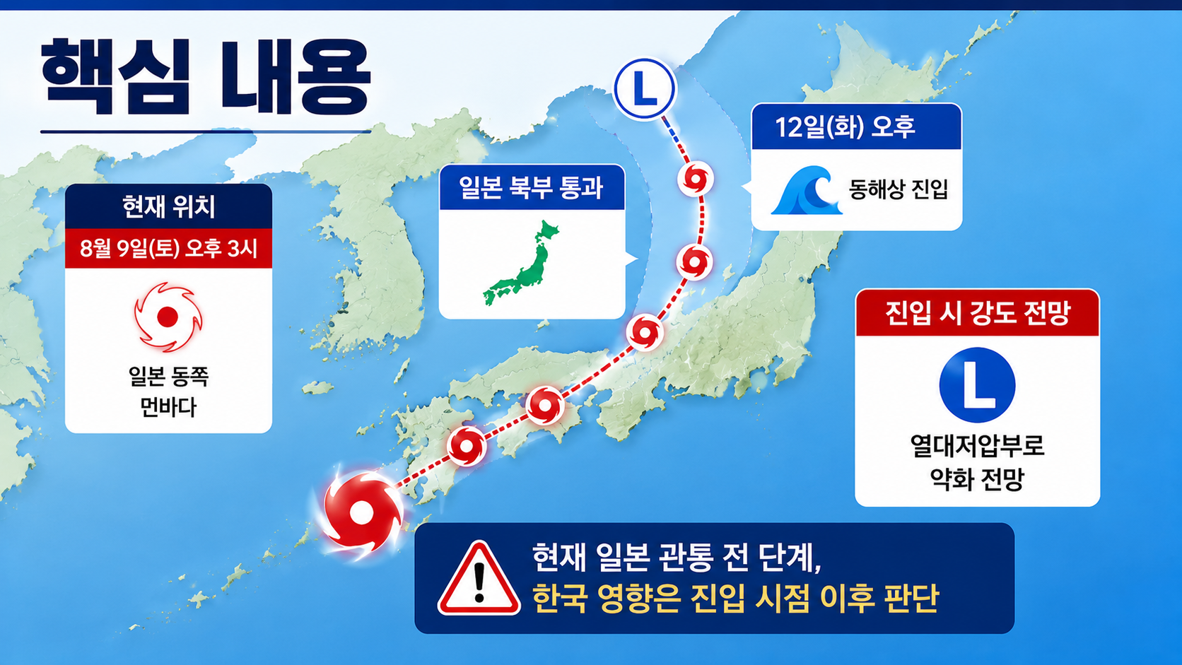
Typhoon Chan-hom, the 15th typhoon of the season, has not yet crossed Japan or entered the East Sea. As of 3 p.m. on August 9, it was over the open waters far east of Japan. According to the latest forecast track, it is expected to weaken into a tropical depression by the time it enters the East Sea on the afternoon of 12, after passing through northern Japan.
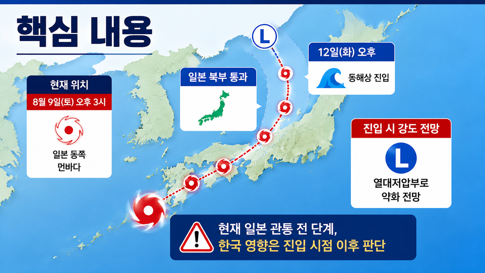
Therefore, the most important question now is not whether Chan-hom will make landfall in South Korea, but how much it will weaken while crossing Japan and what changes it could bring to weather along South Korea's east coast and surrounding waters after entering the East Sea.
Where Was Chan-hom on the Afternoon of August 9?
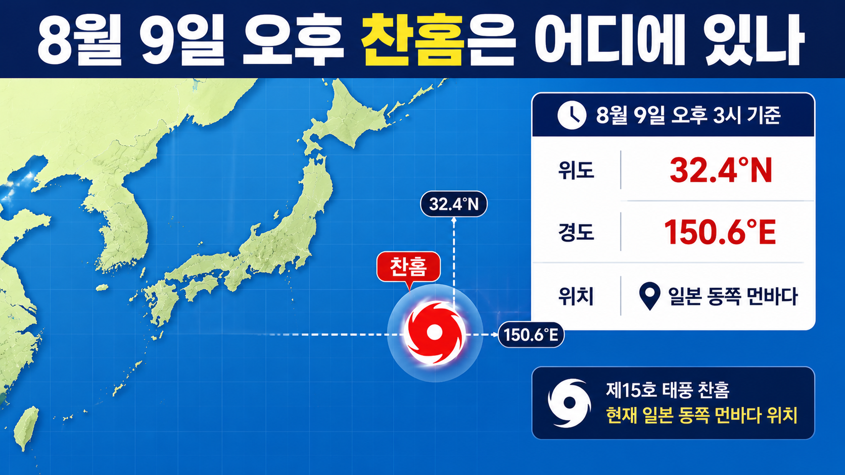
According to the latest typhoon advisory issued at 16:30 on August 9, Chan-hom was located at latitude 32.4°N and longitude 150.6°E as of 3 p.m.
Its central pressure was 994 hPa, with maximum sustained winds of 21 meters per second, equivalent to 76 kilometers per hour. It was moving westward at a relatively slow speed of 6 kilometers per hour, with a strong-wind radius of approximately 300 kilometers.
At around 3 a.m. the same day, it had reportedly been moving at 16 kilometers per hour. By 3 p.m., its forward speed had decreased to 6 kilometers per hour. Comparing the speeds alone, this represents a decrease of 10 km/h, or a slowdown of approximately 62.5%.
Author's calculation:
(16-6) ÷ 16 × 100 = 62.5%
The typhoon's central pressure and maximum wind speed remained largely unchanged from the morning reports, at approximately 994 hPa and 21 meters per second. However, its slower movement has also shifted the forecast timing of its subsequent intensification.
When Will Chan-hom Reach Its Peak Intensity?
The latest forecast indicates that Chan-hom could intensify by another level between the afternoon of 10 and the early morning of 11.
At 3 a.m. on 10, its central pressure is forecast to be 990 hPa, with maximum winds of 24 meters per second. By 3 p.m. on 10, it is expected to strengthen to intensity 2, with central pressure of 985 hPa and maximum winds of 27 meters per second. The projected track indicates that it could maintain similar strength at 3 a.m. on 11.
One important point is that the forecast continues to change slightly with each update.
Some reports published around midday on August 9 indicated that Chan-hom would reach intensity 2 as early as 3 a.m. on 10. However, the latest advisory issued at 16:30 pushed the expected timing of intensity 2 back to 3 p.m. on 10. This is why it is important to check the publication time of the latest forecast rather than relying on an older screenshot of a typhoon track.
Will Chan-hom Really Cross Japan Before Entering the East Sea?
The current forecast track suggests that possibility. However, it is important to distinguish this from a future track that has not yet occurred.
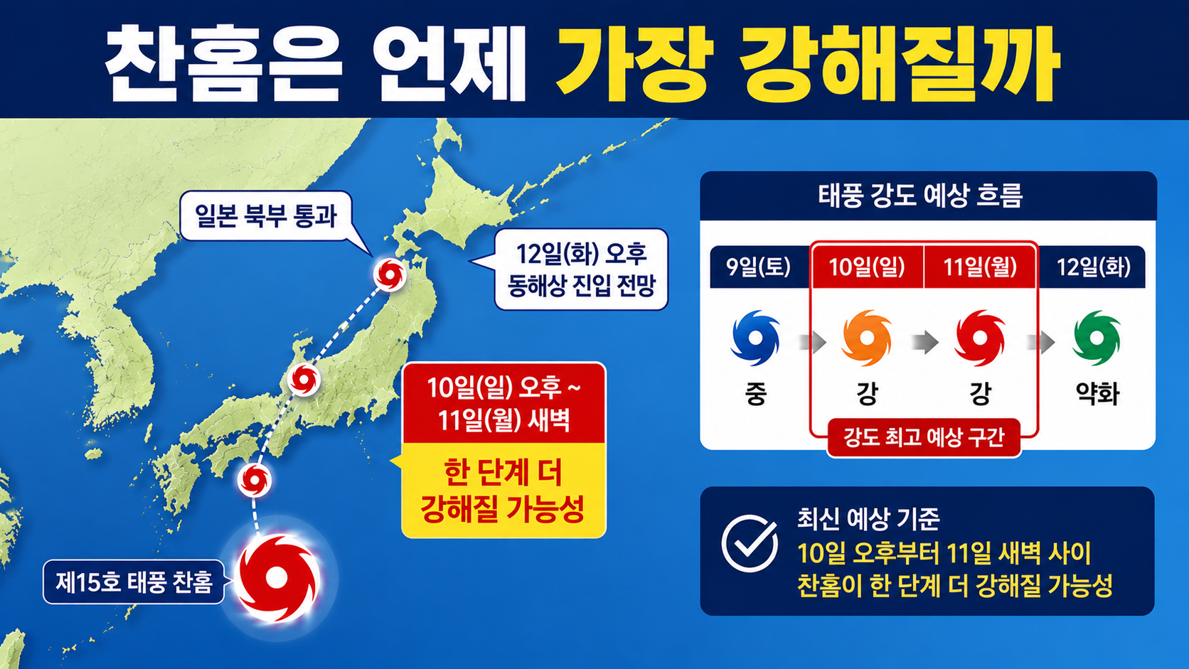
Chan-hom is forecast to reach an area east of Japan near latitude 37.6°N and longitude 142.4°E by 3 p.m. on 11. It is then expected to move westward and reach latitude 37.2°N and longitude 134.9°E by 3 p.m. on 12. Connecting these forecast positions produces a track that crosses northern Honshu, Japan, before emerging into the East Sea.
However, the storm is not expected to retain its typhoon strength all the way into the East Sea.
The Korea Meteorological Administration expects Chan-hom to weaken into a tropical depression within 72 hours. At its forecast position at 3 p.m. on 12, maximum winds are projected to be 15 meters per second, with central pressure of 996 hPa. It is also classified as a tropical depression rather than a typhoon at that point.
Therefore, the phrase 'a typhoon entering the East Sea' could lead readers to overestimate the actual danger. The more accurate interpretation of the current forecast is that Chan-hom is expected to move toward the East Sea after crossing Japan, but it will likely have weakened below typhoon strength by the time it enters those waters.
Could Chan-hom Pass Directly Across South Korea?
Based solely on the forecast track available on the afternoon of August 9, Chan-hom is not expected to cross the Korean Peninsula directly.
The storm's center is projected to move across Japan and into the East Sea, and its current strong-wind radius does not directly extend over the Korean Peninsula. Domestic news reports have also assessed the likelihood of direct typhoon damage to South Korea as low under the current projected track.
However, 'no direct landfall' does not mean 'no changes in the weather.'
The Korea Meteorological Administration's short-range forecast issued on August 9 warns of high waves across most surrounding seas for the time being, along with possible swells along the southern and eastern coasts and the coast of Jeju Island. Rainfall of 5–40 mm is also forecast for the eastern coastal and mountainous areas of Gangwon Province, while 20–60 mm is expected along the eastern coast and in the northeastern mountainous areas of North Gyeongsang Province during 9–10.
However, it would be inaccurate to attribute all current rainfall along the east coast to Chan-hom. Short-range forecasts account for multiple atmospheric pressure systems and easterly winds. It would therefore be more accurate to check the latest forecasts again during 11–12, when the typhoon is expected to move closer.
Will Chan-hom Bring an End to the Heat Wave?
Based on currently available information, a nationwide end to the heat wave is unlikely.
The short-range forecast issued on August 9 also predicted that intense heat and tropical nights would continue across most of the country for the time being. The medium-range outlook for 13–19 projected morning temperatures of 22–26 degrees and daytime temperatures of 29–35 degrees, both above seasonal averages. It also indicated that maximum apparent temperatures could rise to 33 degrees or higher across most regions.
A typhoon or a low-pressure system that has weakened from a typhoon could alter atmospheric conditions over the East Sea, potentially affecting temperatures and rainfall along the east coast. However, if the storm's center does not pass directly across the Korean Peninsula, it is unlikely to bring an end to the heat nationwide all at once.
Weather conditions could differ significantly between the east coast and western regions. Easterly winds may bring cloud cover or rain to the east coast, resulting in relatively lower temperatures, while intense heat and tropical nights could continue across much of the country.
What Should You Check Again Around 12?
Chan-hom is currently moving slowly, and its forecast track has been adjusted repeatedly over the past several days. A difference of several hundred kilometers in a typhoon's track can change which areas experience rain, wind, and high waves. Therefore, conditions on 12 should not be treated as certain based on a single forecast map available today.
The first thing to check is Chan-hom's actual strength as it approaches Japan on 11. It will be important to see whether the storm intensifies to the forecast 27 meters per second and how quickly it weakens after crossing Japanese land areas.
The second is the location where Chan-hom enters the East Sea on 12. According to the forecast issued at 16:30 on August 9, its center is expected to be at latitude 37.2°N and longitude 134.9°E at 3 p.m. on 12.
The third is rainfall along the east coast and marine weather advisories. Anyone planning to swim, fish, visit breakwaters or rocky coastal areas, or travel to Ulleungdo, Dokdo, or destinations served by East Sea shipping routes should check actual high-wave warnings and swell forecasts, not just the position of the typhoon's center. The Korea Meteorological Administration is also currently urging caution over high waves across most surrounding seas and swells along the east coast.
At this point, Chan-hom can be summarized in one statement:
Typhoon Chan-hom, the 15th typhoon of the season, was over the open waters far east of Japan on the afternoon of August 9. It is forecast to intensify temporarily during 10–11 before crossing Japan and weakening into a tropical depression by the time it enters the East Sea on 12. Although the likelihood of it passing directly across the Korean Peninsula is low, the latest forecasts should continue to be monitored for changes in weather along the east coast and at sea.