

2026 Kumamoto Earthquake Magnitude 7.1: Impact on South Korea and Tsunami Advisory Cancellation Time
이 포스팅은 쿠팡 파트너스 활동의 일환으로, 이에 따른 일정액의 수수료를 제공받습니다.
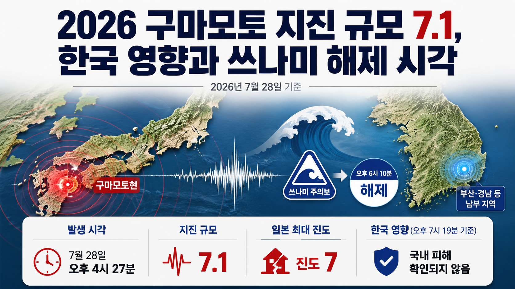
This article is based on the latest available news reports and official information verified as of 2026-07-28 Korea Standard Time.
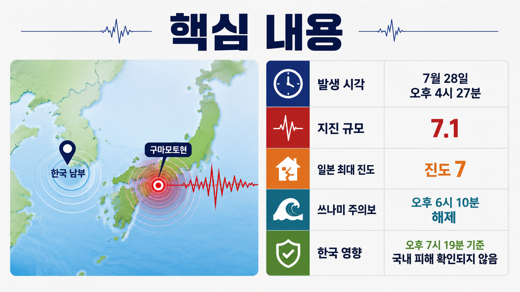
A powerful earthquake measuring 7.1 struck Kumamoto Prefecture, Japan, at 4:27 p.m. on 2026-07-28. A maximum seismic intensity of 7 was recorded in Japan, and a tsunami advisory was issued. However, the advisory was lifted at 6:10 p.m. Tremors were felt in southern South Korea, particularly in Busan and South Gyeongsang Province, but no damage had been confirmed in South Korea as of 7:19 p.m.
Damage reports and transportation conditions may continue to change. If you are planning a trip or business visit to Kyushu, rather than immediately canceling your entire itinerary, check the operating status of your flights, airports, JR trains, and accommodations individually.
When and Where Did the Kumamoto Earthquake Occur?
The earthquake occurred at 4:27 p.m. on July 28, approximately 23 km south of Kumamoto City in Kumamoto Prefecture, Japan.
According to the Korea Meteorological Administration, the earthquake had a magnitude of 7.1 and a focal depth of 10 km. The Japan Meteorological Agency announced that a seismic intensity of 7, the highest level on Japan's seismic intensity scale, was recorded in locations including Uki City and Hikawa Town in Kumamoto Prefecture.
| Category | Confirmed Information |
|---|---|
| Time of occurrence | 2026-07-28, 4:27 p.m. |
| Location | Approximately 23 km south of Kumamoto City |
| Magnitude | 7.1 according to South Korean and Japanese meteorological authorities |
| Depth | Approximately 10 km |
| Maximum seismic intensity in Japan | Seismic intensity 7 |
| Tsunami advisory | Lifted at 6:10 p.m. |
| Situation in South Korea | Tremors detected in southern regions, with no confirmed damage |
At 5:8 p.m., another earthquake measuring 6.1 occurred offshore, approximately 49 km south-southwest of Kumamoto City. Additional earthquakes in the 3\~4 magnitude range followed, meaning residents and visitors must remain alert to falling objects, damaged buildings, and landslides.
Has the Tsunami Advisory Been Lifted?
The tsunami advisory issued for the Ariake Sea and Yatsushiro Sea areas was lifted at 6:10 p.m. Authorities initially warned of possible tsunami waves reaching 1 m, but no actual tsunami was observed.
However, lifting the advisory does not mean that all earthquake-related dangers have ended. Even in inland areas, aftershocks can cause damaged exterior walls, windows, signs, fences, and hillsides to collapse.
If you are in the affected area, the safest approach is to take the following steps in order.
1. Check evacuation information issued by the Japan Meteorological Agency and local governments.
2. Stay away from cracked buildings and walls.
3. Use stairs rather than elevators.
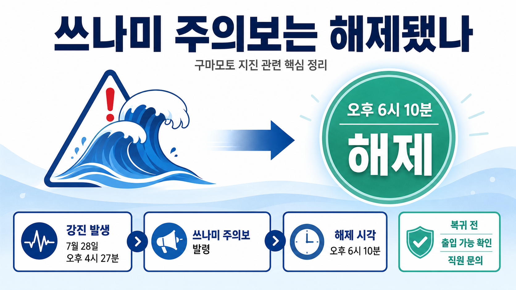
4. If mobile phone networks become congested, contact family and friends through text messages or messaging apps.
5. Before returning to your accommodation, ask staff whether it is safe to enter the building.
Why Were Tremors Also Felt in South Korea?
Kumamoto is located in western Kyushu, relatively close to the southern Korean Peninsula. Seismic waves generated by the powerful earthquake traveled through the sea and Earth's crust, reaching areas including Busan, South Gyeongsang Province, Ulsan, South Jeolla Province, and Jeju.
Data from the Korea Meteorological Administration showed instrumental seismic intensity levels of Ⅲ in parts of South Gyeongsang Province, Busan, South Jeolla Province and Gwangju, and Jeju. An instrumental intensity of Ⅲ indicates shaking that people indoors or on upper floors of buildings can feel relatively clearly, while stationary vehicles may sway slightly.
By 6:29 p.m., South Korean authorities had received 789 reports from people who felt the shaking. Busan accounted for the largest number, with 291 reports, followed by reports from South Gyeongsang Province, Changwon, and other areas in the Yeongnam region. No damage to facilities or injuries in South Korea had been confirmed by that time.
If you felt the shaking, check for the smell of gas, cracks in walls, and detached ceiling materials. If you suspect structural damage, contact your building management office or the fire authorities. It is safer not to approach damaged areas to touch cracks or attempt repairs yourself.
Magnitude 7.1 and Seismic Intensity 7 Are Not the Same Measurement
Magnitude represents the amount of energy released by an earthquake itself. In principle, a single earthquake is assigned one representative magnitude.
Seismic intensity describes how strongly the ground actually shakes at a particular location. Even during the same earthquake, intensity varies by area depending on distance from the epicenter, ground conditions, and building height.
| Category | Magnitude | Seismic Intensity |
|---|---|---|
| Meaning | Total energy released by an earthquake | Shaking experienced at a specific location |
| This earthquake | 7.1 | Maximum seismic intensity of 7 in Japan |
| Regional differences | A representative value is used | Varies by location |
| How to interpret the number | Logarithmic scale | Observed level of shaking |
Some international agencies revised the earthquake's magnitude to 6.8. The difference from the 7.1 reported by South Korean and Japanese meteorological authorities may reflect differences in the seismic wave data, magnitude calculation methods, and analysis times used by each agency. Rather than assuming one number is incorrect, it is important to distinguish between preliminary estimates and analyzed values calculated using different standards.
This article uses the magnitude of 7.1 reported by the Korea Meteorological Administration and the Japan Meteorological Agency, which is easier for readers in South Korea to verify.
How Powerful Was the Additional Magnitude 6.1 Earthquake?
The magnitude 6.1 earthquake that occurred at 5:8 p.m. was also strong enough to damage buildings and transportation infrastructure. However, because earthquake magnitude is measured on a logarithmic scale, the difference between magnitudes 7.1 and 6.1 should not be interpreted simply as a difference of approximately 16%.
Author's Calculation
Reference values: Magnitude 7.1 and magnitude 6.1
Magnitude difference: 1.0
Formula: 10^(1.5×1.0)
Calculation result: Approximately 31.6
Using the standard magnitude-to-energy conversion formula, the magnitude 7.1 earthquake released approximately 32 times more energy than the magnitude 6.1 earthquake. Conversely, this does not mean the magnitude 6.1 earthquake was too small to be concerned about. Even smaller aftershocks can cause additional damage to buildings that have already been weakened.
Local Damage and Transportation Conditions in Japan
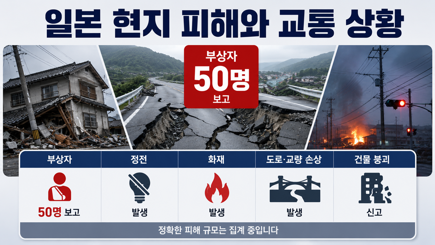
Reports confirmed by 7:19 p.m. indicated that at least 50 people had been injured. Reports of power outages, fires, damaged roads and bridges, and collapsed buildings continued to emerge, while authorities were still assessing the full extent of the damage.
Tens of thousands of households in the Kumamoto area experienced power outages, and some mobile communication services were disrupted. Train services, including the Kyushu Shinkansen and Nishi Kyushu Shinkansen, were suspended. Flight cancellations and diversions also occurred as Kumamoto Airport inspected its runway.
Damage was also reported to sections of the stone walls at Kumamoto Castle, roads, and commercial facilities. No immediate abnormalities were confirmed at nuclear-related facilities, but the results of additional inspections by the relevant authorities should be checked separately.
The numbers of injured people and households without electricity, as well as the sections of railway lines affected by service suspensions, may continue to change as recovery work progresses. Initial figures should not be cited as the final extent of the damage.
Should You Cancel Your Trip to Kyushu?
Not all parts of Kyushu experienced the same level of damage, so travelers should assess conditions based on their specific destinations. If you plan to visit areas close to the epicenter, including Kumamoto City, Uki City, Yatsushiro City, and Amakusa, it is advisable to remain particularly flexible about changing your itinerary.
Even if you are visiting destinations farther from the epicenter, such as Fukuoka or Oita, your travel route may be disrupted if your itinerary involves the Kyushu Shinkansen or Kumamoto Airport.
Before traveling, check the following five items in order.
Flights: Check your airline's app for cancellations, delays, or changes to arrival destinations.
Airport: Confirm the operating status of Kumamoto Airport's runway and terminal.
Railways: Check which Shinkansen and conventional railway sections JR Kyushu is operating.
Accommodation: Confirm whether the building has passed safety inspections and whether check-in is possible.
Travel insurance: Review coverage conditions for cancellations and delays caused by natural disasters.
Do not cancel your plans solely on the basis of information seen in online posts or messaging apps. Confirm the situation directly with your airline and accommodation provider. If your flight is operating normally but you decide to cancel it yourself, standard cancellation fees may apply.

Conversely, if an official flight cancellation or accommodation closure is confirmed, it is advisable to save a screenshot of the notice. Refunds or travel insur
이 포스팅은 쿠팡 파트너스 활동의 일환으로, 이에 따른 일정액의 수수료를 제공받습니다.