
Latest Track of Typhoon 13 Dolphin: Forecast Position on August 9 and Impact on South Korea and Jeju
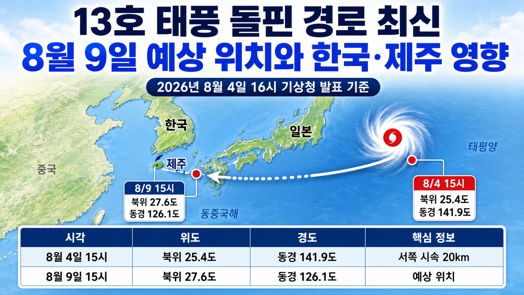
Based on current search results, 'Dolpil track' appears to be a typo for the track of Typhoon No. 13 Dolphin (DOLPHIN). According to the Korea Meteorological Administration (KMA) forecast issued at 16 on 2026-08-04, Dolphin was moving westward at 20 km/h from latitude 25.4°N and longitude 141.9°E at 15 on 4. By 15 on 9, it is forecast to reach latitude 27.6°N and longitude 126.1°E. However, forecast uncertainty remains high, and its potential impact on South Korea and Jeju cannot yet be determined.
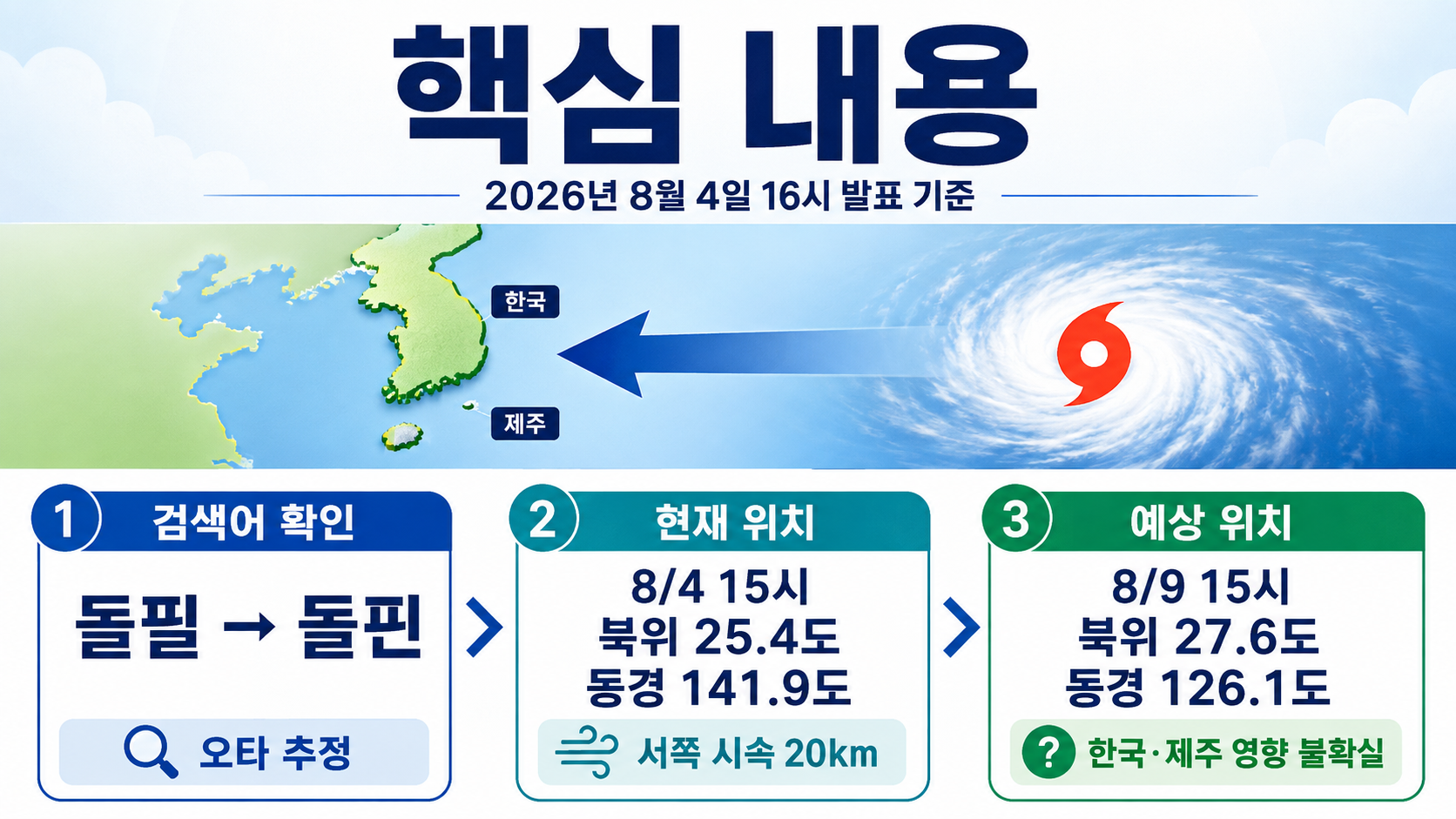
What Are Typhoon Dolphin's Current Position and Intensity?
As of 15 on August 4, Typhoon Dolphin is a Category 3 typhoon with a central pressure of 950 hPa and maximum sustained winds near its center of 43 m/s. Converted to kilometers per hour, its maximum wind speed is 155 km/h, placing it near the upper end of the Category 3 intensity range.
| Category | Current Conditions at 15 on August 4 |
|---|---|
| Center position | Latitude 25.4°N, longitude 141.9°E |
| Direction of movement | West |
| Movement speed | 20 km/h |
| Central pressure | 950 hPa |
| Maximum wind speed | 43 m/s; 155 km/h |
| Typhoon intensity | Category 3 |
| Strong-wind radius | 450 km |
| Storm-force wind radius | 140 km |
The strong-wind radius of 450 km refers to the area extending from the typhoon's center where winds of at least 15 m/s may occur. The storm-force wind radius of 140 km indicates the area where stronger winds of at least 25 m/s are expected.
Even if the typhoon's center does not pass directly over a particular area, locations within its strong-wind radius may experience powerful winds and high waves. Therefore, the single center-track line shown on a map should not be used as the sole basis for assessing potential impacts.
Where Will Dolphin Move by August 9?
The current KMA forecast indicates that Dolphin will move westward during 5–6, then pass through waters near Okinawa during 7–8 before entering the East China Sea. Its forecast center on 9 is south of Jeju Island, but the uncertainty surrounding its position increases with the forecast period.
| Forecast Time | Center Position | Maximum Wind Speed | Central Pressure | Direction and Speed | 70% Probability Radius |
|---|---|---|---|---|---|
| August 5 15 | 25.5°N, 137.1°E | 43 m/s | 950 hPa | West, 19 km/h | 80 km |
| August 6 15 | 26.0°N, 132.9°E | 43 m/s | 950 hPa | West, 18 km/h | 130 km |
| August 7 15 | 26.5°N, 129.4°E | 43 m/s | 950 hPa | West, 15 km/h | 190 km |
| August 8 15 | 27.0°N, 127.3°E | 40 m/s | 955 hPa | West-northwest, 9 km/h | 290 km |
| August 9 15 | 27.6°N, 126.1°E | 39 m/s | 960 hPa | West-northwest, 6 km/h | 440 km |
The 70% probability radius does not represent the typhoon's impact zone or the extent of potential damage. It indicates the forecast area within which the typhoon's center may be located. By 9, this radius expands to 440 km.
The centerline of the forecast track is not a path the typhoon is guaranteed to follow. Both the centerline and forecast positions may be adjusted when new advisories are issued.
Will Typhoon Dolphin Directly Affect South Korea and Jeju?
The forecast centerline issued at 16 on August 4 does not indicate a landfall location on the Korean Peninsula. The forecast center for 9 also remains over waters south of Jeju Island. At this stage, neither landfall in South Korea nor a direct passage over Jeju can be confirmed.
However, it is also too early to conclude that South Korea will experience no impact, for three reasons.
First, the 70% probability radius for the forecast position on 9 is 440 km. The longer the forecast period, the greater the possibility that the actual center position will differ from the currently projected centerline.
Second, the forecast strong-wind radius on 9 is 390 km. Even if the typhoon's center passes some distance from Jeju, a northward adjustment to its track or an expansion of its strong-wind radius could affect southern waters and the seas around Jeju first.
Third, local rainfall and wind conditions are not determined solely by the typhoon's center. Surrounding pressure systems, moisture inflow, the typhoon's movement speed, and its strong-wind radius must also be considered.
Therefore, the most practical approach is to check typhoon advisories issued after 7 alongside local land and marine forecasts when assessing possible impacts on South Korea and Jeju.
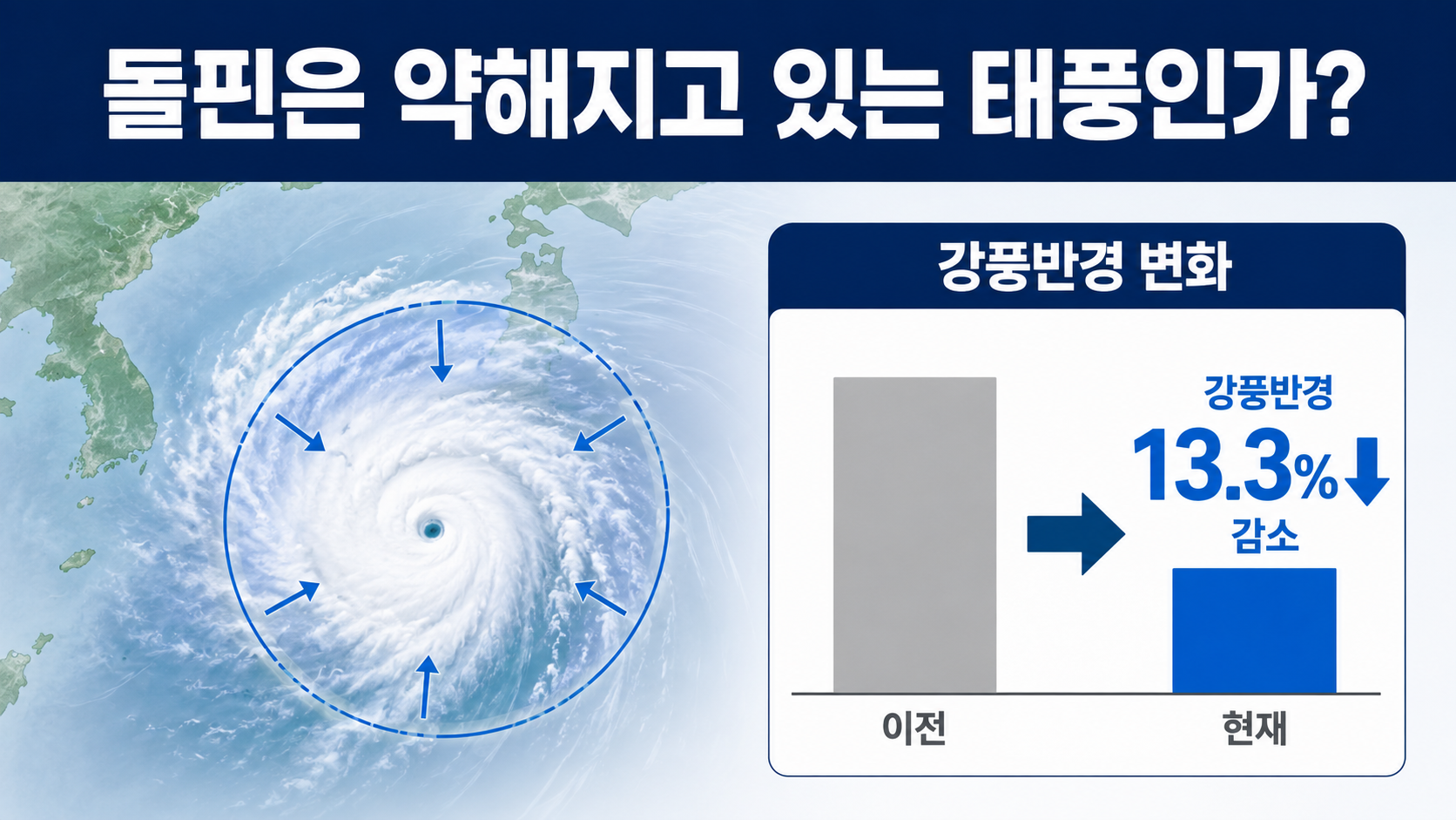
Is Typhoon Dolphin Weakening?
The current forecast suggests that Dolphin will maintain Category 3 intensity through August 9 while its maximum wind speed and strong-wind radius gradually decrease. Although some weakening is expected, a maximum wind speed of 39 m/s still corresponds to Category 3 intensity.
| Indicator | Current on August 4 | Forecast for August 9 | Change |
|---|---|---|---|
| Maximum wind speed | 43 m/s | 39 m/s | Decrease of 4 m/s |
| Central pressure | 950 hPa | 960 hPa | Increase of 10 hPa |
| Strong-wind radius | 450 km | 390 km | Decrease of 60 km |
| Storm-force wind radius | 140 km | 110 km | Decrease of 30 km |
According to the author's calculations, maximum wind speed decreases by approximately 9.3%.
The calculation is `(39-43)÷43×100=-9.3%`.
The strong-wind radius decreases by approximately 13.3%.
The calculation is `(390-450)÷450×100=-13.3%`.
Declining figures do not mean precautions are unnecessary. Areas along the forecast track or near the typhoon's actual approach should separately monitor wind gusts, rainfall, high waves, and transportation restrictions, rather than focusing only on maximum wind speed.
Why Do News Reports Show Different Tracks for Dolphin?
The differences arise because reports use advisories issued at different times or forecasts from different meteorological agencies. Even articles with similar headlines may rely on data from the previous day or an earlier morning advisory, resulting in differences in position, movement speed, and projected track compared with the latest KMA information.
When checking a typhoon's track, the following sequence is recommended.
1. Check the KMA advisory issuance time cited in the article, rather than relying solely on the article's publication date.
2. Check the current position and scheduled time of the next update in the KMA typhoon advisory.
3. Examine the 70% probability radius as well as the forecast centerline.
4. Check whether the strong-wind and storm-force wind radii are approaching the area you plan to visit.
5. If you have travel plans, also check announcements from airlines, ferry operators, and local governments.
European and American numerical weather prediction models can be useful references, but a single model run at one particular time should not be treated as a confirmed track.
When Should Travelers to Okinawa or Jeju Check for Updates?
Travelers heading to Okinawa should frequently check flight and ferry operating notices because Dolphin's forecast track may approach the area during 7–8. For Jeju trips, it is more reasonable to monitor whether local rainfall, wind, and marine forecasts become clearer after 7 than to cancel based solely on the current forecast.
Traveling to Okinawa
Check flight departure and arrival notices for 7–8.
Confirm whether outdoor sightseeing attractions and marine activities will operate.
Save your accommodation provider's typhoon-related cancellation and modification policies in advance.
Check additional accommodation costs and travel insurance coverage conditions in case your return flight is delayed.
Traveling to Jeju and South Korea's Southern Coast
Check KMA typhoon advisories alongside Jeju's regional forecasts.
Recheck passenger ferry services and transportation to islands both the day before departure and on the departure date.
Prioritize marine weather warnings when planning coastal walks, visits to breakwaters, or fishing trips.
Avoid leaving vehicles for extended periods in underground parking facilities or near rivers where flooding is possible.
There is no need to rush into canceling travel plans based solely on the current track, but it is advisable to check in advance when cancellation fees may change.
Important Dates and Updates to Check Now
Around 22 on August 4: Next KMA typhoon information update scheduled
August 5–6: Check whether Dolphin maintains its westward movement speed and projected approach toward Okinawa
After August 7: Check regional forecasts and marine weather warnings for Jeju and the southern coast
The day before departure and on departure day: Recheck operating notices from airlines and ferry operators
If a new advisory shifts the forecast center northward, indicates slower movement, or expands the strong-wind radius, the possibility of impacts on South Korea should be reassessed.
Frequently Asked Questions
Do 'Dolpil Track' and 'Dolphin Track' Mean the Same Thing?
Based on current search patterns, 'Dolpil track' appears to be a misspelling of the track of Typhoon No. 13 Dolphin. The official typhoon name is Dolphin (DOLPHIN).
Has Typhoon Dolphin's Landfall in South Korea Been Confirmed?
No. The KMA advisory issued at 16 on August 4 does not indicate landfall on the Korean Peninsula. Because long-range forecasts have substantial positional uncertainty, subsequent advisories should be monitored continuously.
Will Typhoon Dolphin Pass Over Jeju Island?
The current forecast places the typhoon's center over waters south of Jeju Island on 9. A direct passage over Jeju has not been confirmed. It is important to monitor whether the track shifts northward and to check marine forecasts for the Jeju area.
Will the Heat Wave End When Dolphin Arrives?
It is too early to say. Depending on the typhoon's position and surrounding pressure systems, cloud cover and rainfall could increase. Conversely, hot and humid air could also flow into the region. Changes in heat-wave conditions should be assessed using the latest local temperature and precipitation forecasts rather than the typhoon's track alone.
Where Can I Find the Most Accurate Typhoon Track Information?
For assessing impacts on South Korea, KMA typhoon advisories should be the primary reference. These should then be checked alongside land and marine forecasts, weather warnings, and transportation notices for your home or travel destination.
※ This article is based on the KMA advisory issued at 16 and checked at 17:48 Korea Standard Time on 2026-08-04. The typhoon's position, intensity, and forecast track may change in subsequent advisories.