

Latest Guatemala Fuego Volcano Eruption: Red Alerts in 3 Departments, Approximately 1,700 Evacuated
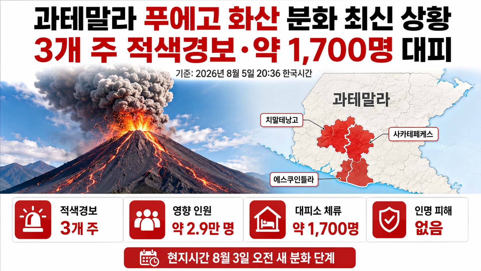
Red alerts have been issued in the 3 Guatemalan departments of Sacatepéquez, Chimaltenango, and Escuintla following the eruption of Fuego Volcano. As of 2026-08-05 at 20:36 Korea Standard Time, approximately 29 thousand people had been affected by volcanic ash and other hazards, approximately 1,700 people were staying in shelters, and no casualties had been confirmed.
Current Confirmed Situation at Fuego Volcano
Fuego Volcano entered a new eruptive phase on the morning of August 3 local time and continued releasing volcanic ash, gases, and lava. As the eruption intensified, hot pyroclastic flows descended through several valleys, prompting authorities to expand precautionary evacuations of nearby residents.
| Category | Confirmed Information as of August 5 |
|---|---|
| Departments under red alert | Sacatepéquez, Chimaltenango, and Escuintla |
| Nationwide alert | Orange alert |
| Evacuated and sheltered population | Approximately 1,700 people |
| Affected population | Approximately 29 thousand people |
| Pyroclastic flows | May travel up to 5–7 km along valleys |
| Volcanic ash plume | Approximately 5–7 km above sea level |
| Ash dispersion | Observed up to approximately 120 km west and northwest |
| Casualties | No confirmed deaths |
| Major risks | Additional explosions and rainfall-triggered lahars |
The three areas under red alert are 1-level administrative divisions of Guatemala surrounding Fuego Volcano. While an orange alert remains in effect nationwide, the emergency response level in the three departments closest to the volcano has been raised to its highest level.
Why Reports of '1 Thousand Residents Evacuated' Differ from the Approximately 1,700 Figure
Evacuation numbers increased rapidly, causing reported figures to vary depending on when they were released. According to an announcement by Guatemala's disaster management authorities on August 4 local time, 659 people had been evacuated by 9 a.m., while 280 people were recorded as staying in shelters.
By 1:50 p.m., the number of evacuated and sheltered people had risen to 1,421. In an update issued at 4:50 p.m., the number of people receiving protection in shelters was revised to 1,699. The figure of 'more than 1 thousand' reported in South Korea reflected an earlier stage of the count. This article uses the subsequently confirmed figure of approximately 1,700 people.
However, the categories of 'people evacuated' and 'people currently staying in shelters' differ slightly between announcements. The figure of approximately 1,700 may change again when new official statistics become available.
What Immediate Dangers Prompted the Red Alerts?
The greatest concerns are pyroclastic flows and lahars rather than lava itself. Pyroclastic flows are fast-moving mixtures of extremely hot volcanic gases, ash, and rock that rush down volcanic slopes, making escape difficult for anyone in their path.
Guatemala's National Institute of Seismology, Volcanology, Meteorology and Hydrology reported repeated pyroclastic flows in several valleys, including Seca, Taniluyá, Ceniza, Las Lajas, and Honda. The potential travel distance of these flows was estimated at approximately 5–7 km, with villages on the western and southwestern slopes identified as particularly vulnerable.
Lahars are volcanic mudflows formed when rainwater mixes with volcanic ash and rocks and travels down valleys or river channels. Guatemala is currently experiencing the rainy season, meaning hazards near valleys and waterways may persist even if volcanic activity temporarily weakens.
How Far Has the Volcanic Ash Spread?
Official observations on August 4 indicated that volcanic ash had spread approximately 120 km toward the west and northwest. The ash plume was reported to have reached an altitude of approximately 5–7 km above sea level.
In nearby communities, volcanic ash can irritate the respiratory system and eyes and contaminate drinking water and food. Heavy accumulation can also increase roof loads and reduce visibility on roads.
Guatemala's disaster management authorities advised residents to cover water and food containers and protect their noses and mouths with masks or damp cloths. People should avoid valleys and rivers and immediately move to designated shelters if evacuation orders are issued.
Is It Safe to Travel Near Fuego Volcano?
Access to and climbing on Fuego Volcano should currently be avoided. Authorities in Chimaltenango have also imposed climbing restrictions on nearby Acatenango Volcano. Even travelers with existing tour reservations should prioritize official restrictions over guidance from local tour operators.
National Highway 14, which passes near the volcano, was temporarily closed as a precaution before reopening after volcanic activity decreased somewhat. However, restrictions may change again depending on eruption activity, volcanic ash, or lahar risks. Travelers should check announcements from Guatemala's road authorities immediately before departure.
As of the reporting cutoff, no direct flight disruptions had been reported at the international airport serving the capital region. Because wind conditions can change the direction of volcanic ash movement, visitors to Guatemala City and Antigua should also check airline flight notifications and airport announcements separately.
School Closures and Shelter Operations
Guatemala's education authorities suspended in-person classes at schools in Escuintla, San Juan Alotenango, and Acatenango on August 5. The precautionary measure covers both public and private schools and may be extended depending on volcanic activity and ash conditions.
Emergency shelters have been established in San Juan Alotenango, Santa Lucía Cotzumalguapa, Escuintla, and other locations. Evacuated residents are receiving meals, medical assistance, hygiene supplies, psychological support, and other services.
Is the Number of Evacuees Higher Than During Previous Eruptions?
During the 2023 eruption of Fuego Volcano, approximately 1,200 people were evacuated. During the current eruption in 2026, approximately 1,700 people were reported to be staying in shelters.
According to the author's calculation, the current evacuation figure is approximately 500 people higher than in 2023, representing an increase of approximately 41.7%.
The calculation is '(1,700 people - 1,200 people) ÷ 1,200 people × 100'. However, the reporting times, geographic coverage of evacuations, and criteria for counting shelter occupants differ between the two eruptions. Therefore, this calculation alone cannot be used to determine the relative intensity of the eruptions.
The 2018 eruption of Fuego Volcano caused a major disaster in which more than 200 people died. The experience of that disaster, together with the dangers posed by pyroclastic flows, likely contributed to the expansion of precautionary evacuations during the current eruption.
Which Official Updates Should Be Monitored First?
During a local briefing on August 4, officials indicated that volcanic activity could continue for approximately two more days. This was not a definitive prediction of when the eruption would end. Actual activity could last longer or weaken sooner depending on subsequent observations.
Going forward, the following factors should be monitored alongside the intensity of Fuego Volcano's explosions.
Distance and direction of pyroclastic flows
Whether rainfall triggers lahars
Whether red alerts remain in effect or are lifted in the three departments
Shelter occupancy figures and decisions on residents returning home
Restrictions on National Highway 14 and climbing Acatenango Volcano
Direction of volcanic ash movement and impacts on flights
Local residents and travelers should rely on the latest guidance from Guatemala's National Coordinator for Disaster Reduction (CONRED) and the National Institute of Seismology, Volcanology, Meteorology and Hydrology (INSIVUMEH) as their primary official sources. In an emergency, people in Guatemala should call the national disaster emergency number 119 or contact local rescue authorities.