

Typhoon 16 Peilou Forecast Track: Moving Away from South Korea, Expected to Weaken Within 48 Hours
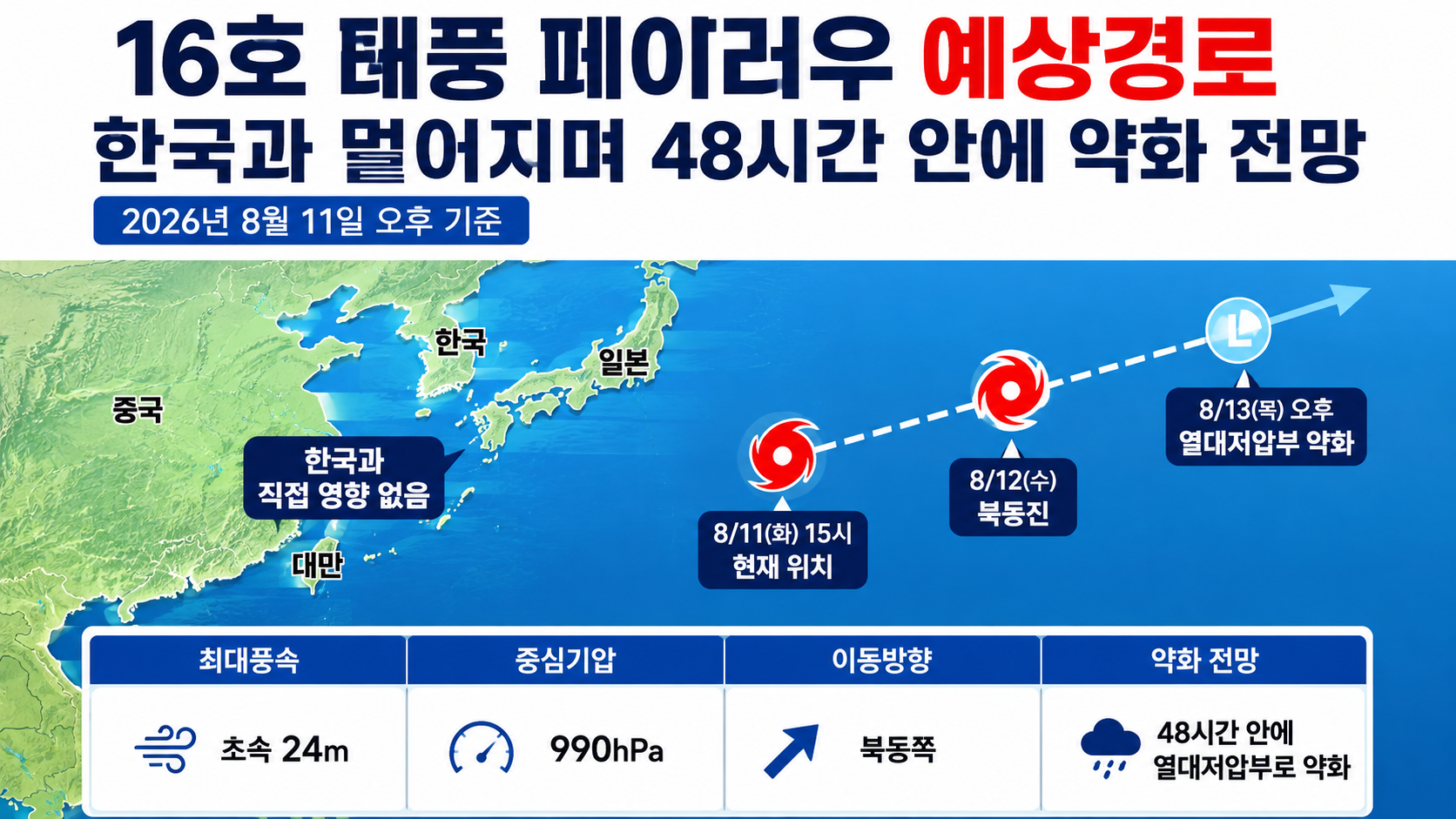
As of the afternoon of 2026-08-11, Typhoon No. 16 Peilou (PEILOU) is not approaching South Korea. At 3 p.m. on 11, its maximum sustained wind speed was 24m per second, with a central pressure of 990hPa, and it was moving northeast. According to the latest forecast, it is expected to weaken into a tropical depression by the afternoon of 13.
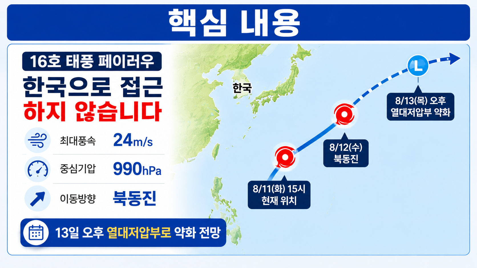
The most important precaution when searching for information is to avoid mixing the forecast track from several days ago, when the storm first formed, with its current track. Since Peilou formed on August 9, both its position and forecast intensity have been repeatedly revised. Information issued at 16:30 on August 11 showed a clearer trend of the storm moving northeast while gradually weakening.
Where Is Typhoon 16 Peilou Now?
As of 3 p.m. on August 11, Peilou's center was located at 25.8° north latitude and 157.1° east longitude. Its central pressure was 990hPa, maximum sustained winds near the center were 24m per second, or 86km per hour, and its radius of strong winds was approximately 240km. The storm was moving northeast at 32km per hour.
At this location, the most important factor is not simply its latitude but its direction of movement. Peilou is moving northeast rather than west or northwest toward the Korean Peninsula.
By 3 a.m. on August 12, it is forecast to reach 27.9° north latitude and 160.1° east longitude. By 3 p.m. that same day, it is expected to reach 30.1° north latitude and 162.1° east longitude. Its movement is expected to continue east-northeast on 13.
Therefore, based solely on the current forecast track, Peilou is not moving closer to the Korean Peninsula over time. Instead, its projected path takes it northeastward across the western Pacific.
How Likely Is Typhoon 16 to Reach South Korea?
The currently published forecast track does not indicate that Peilou will directly approach the Korean Peninsula. Both the storm's present direction and its projected future positions point northeast to east-northeast, away from South Korea.
Related reports published through August 10 also indicated that winds around Peilou were directed eastward rather than toward the Korean Peninsula, suggesting a low likelihood of direct impacts on South Korea.
However, 'no direct impact on South Korea' does not mean 'South Korea's weather will definitely remain unchanged.'
Even when a typhoon is far away, the positions of surrounding high-pressure systems, other tropical cyclones, moisture left behind by the storm, and changes in atmospheric pressure patterns can affect weather in South Korea. This is particularly important when several typhoons exist in the western Pacific at the same time, as their individual movements and weakening processes must also be considered. Domestic rainfall or wind conditions should not be attributed entirely to Typhoon 16 Peilou.
For now, rather than worrying about Peilou making landfall or South Korea entering its strong-wind radius, the more accurate approach is to check the latest domestic weather forecasts separately.
When Will Peilou Weaken Below Typhoon Strength?
According to the current forecast, Peilou is expected to weaken into a tropical depression (TD) around 3 p.m. on August 13. In the forecast issued at 16:30 on 11, meteorological authorities also expected it to weaken into a tropical depression within 48 hours.
The projected changes in intensity are relatively clear.
At 3 p.m. on August 11, maximum sustained winds were 24m per second. They are forecast to decrease to 21m per second at 3 a.m. on 12, 20m per second at 3 p.m. that day, and 19m per second at 3 a.m. on 13. By 3 p.m. on 13, Peilou is expected to become a tropical depression with maximum sustained winds of approximately 15m per second.
Author's calculation:
As maximum sustained winds decrease from 24m/s to 15m/s, the reduction is 9m/s.
`(24 - 15) ÷ 24 × 100 = 37.5%`
Assuming the current forecast holds, maximum sustained winds near the storm's center would decrease by approximately 37.5% over roughly 48 hours.
Central pressure shows the same weakening trend. It is forecast to rise from 990hPa on the afternoon of 11 to 994hPa on the morning of 12, 996hPa that afternoon, 998hPa on the morning of 13, and 1000hPa by the afternoon of 13.
Generally, typhoons are stronger when their central pressure is lower and their maximum sustained winds are higher. These forecast values therefore indicate that Peilou's circulation is expected to weaken over time.
Why Was the Expected Weakening Delayed Compared with the Initial Forecast?
Peilou's forecast has been gradually revised since its formation. When the storm was first reported on August 9, it was expected that it might weaken into a tropical depression around the afternoon of 12. However, the latest outlook on August 11 indicates that it will retain typhoon strength somewhat longer, with the transition to a tropical depression now forecast for the afternoon of 13.
This difference is better understood as part of the ongoing process of adjusting predicted positions and intensity as new observations become available, rather than simply concluding that the original typhoon forecast was wrong.
When Peilou formed at 3 p.m. on August 9, its maximum sustained winds were 19m per second and its central pressure was 998hPa. It subsequently intensified temporarily, reaching maximum sustained winds of 24m per second and a central pressure of 990hPa by the afternoon of August 11.
In other words, Peilou did not begin weakening immediately after forming. It first intensified somewhat before moving northeast and gradually weakening.
For this reason, when reviewing typhoon information, it is more useful to check whether the current maximum sustained winds and the forecasts for the next 12 hours and 24 hours are actually declining than to rely on a single statement that the storm will disappear in a few days.
What Does the Name Peilou Mean?
The international name of Typhoon No. 16 is Peilou (PEILOU). The name was submitted by Macau and refers to a type of bird.
It is also important to distinguish between a typhoon's number and its name. 'Typhoon No. 16' is the sequential designation assigned to the storm in the northwestern Pacific during 2026, while 'Peilou' is its internationally recognized name.
Therefore, search results labeled 'Typhoon No. 16,' 'Typhoon No. 16 Peilou,' or 'Typhoon Peilou' all refer to the same storm.
What Matters Now Is Whether the Direction Changes, Not Just the Track
Under current conditions, the most important development to watch is not simply whether Peilou suddenly intensifies, but whether its forecast movement is substantially revised westward.
According to the forecast as of the afternoon of August 11, Peilou will move northeast from 11 through 12 before turning east-northeast on 13. Its projected longitude also shifts progressively eastward, from 157.1° east to 160.1°, 162.1°, 163.6°, and 167.2° east.
The change in longitude alone makes the direction clear.
Author's calculation: If Peilou moves from 157.1° east longitude at 3 p.m. on 11 to 167.2° east longitude at 3 p.m. on 13, its center will shift 10.1 degrees eastward in longitude over approximately 48 hours.
Of course, typhoon forecast tracks contain uncertainty. The '70% probability radius' shown in meteorological forecasts represents an area within which the storm's center is likely to be located. Therefore, a single plotted forecast position should not be treated as a guaranteed track. The 70% probability radius is 40km for the forecast position on the morning of 12, widening to 80km that afternoon and 110km on the morning of 13. By the afternoon of 13, it reaches 130km.
Even after accounting for the current degree of forecast uncertainty and the storm's direction of movement, a major westward reversal toward the Korean Peninsula is not the central scenario in the current forecast.
When Should You Check for Another Update on Typhoon 16?
The next typhoon advisory is scheduled to be issued around 10:30 on the afternoon of August 11.
In the next update, three factors deserve attention before minor 1-to-2-step changes in central pressure or wind speed:
Whether the storm continues moving northeast or east-northeast.
Whether the expected weakening into a tropical depression is moved earlier or later than 13.
Whether the probability radius of the forecast track expands significantly toward the Korean Peninsula.
The trend confirmed so far is relatively straightforward. Typhoon No. 16 Peilou was moving northeast on the afternoon of August 11 with maximum sustained winds of 24m per second. Rather than approaching South Korea, it is expected to move toward the northeastern part of the western Pacific and will likely weaken into a tropical depression by the afternoon of 13.
If the current track holds, there is no immediate reason to be concerned about direct typhoon damage from Peilou itself in South Korea. However, typhoon tracks can be revised whenever new observational data become available, so it is advisable to check again using the next advisory scheduled for the night of August 11.
---