

Typhoon Dolphin No. 13: Current Location, Forecast Track, and Why It Is Too Early to Assess Its Impact on the Korean Peninsula
이 포스팅은 쿠팡 파트너스 활동의 일환으로, 이에 따른 일정액의 수수료를 제공받습니다.
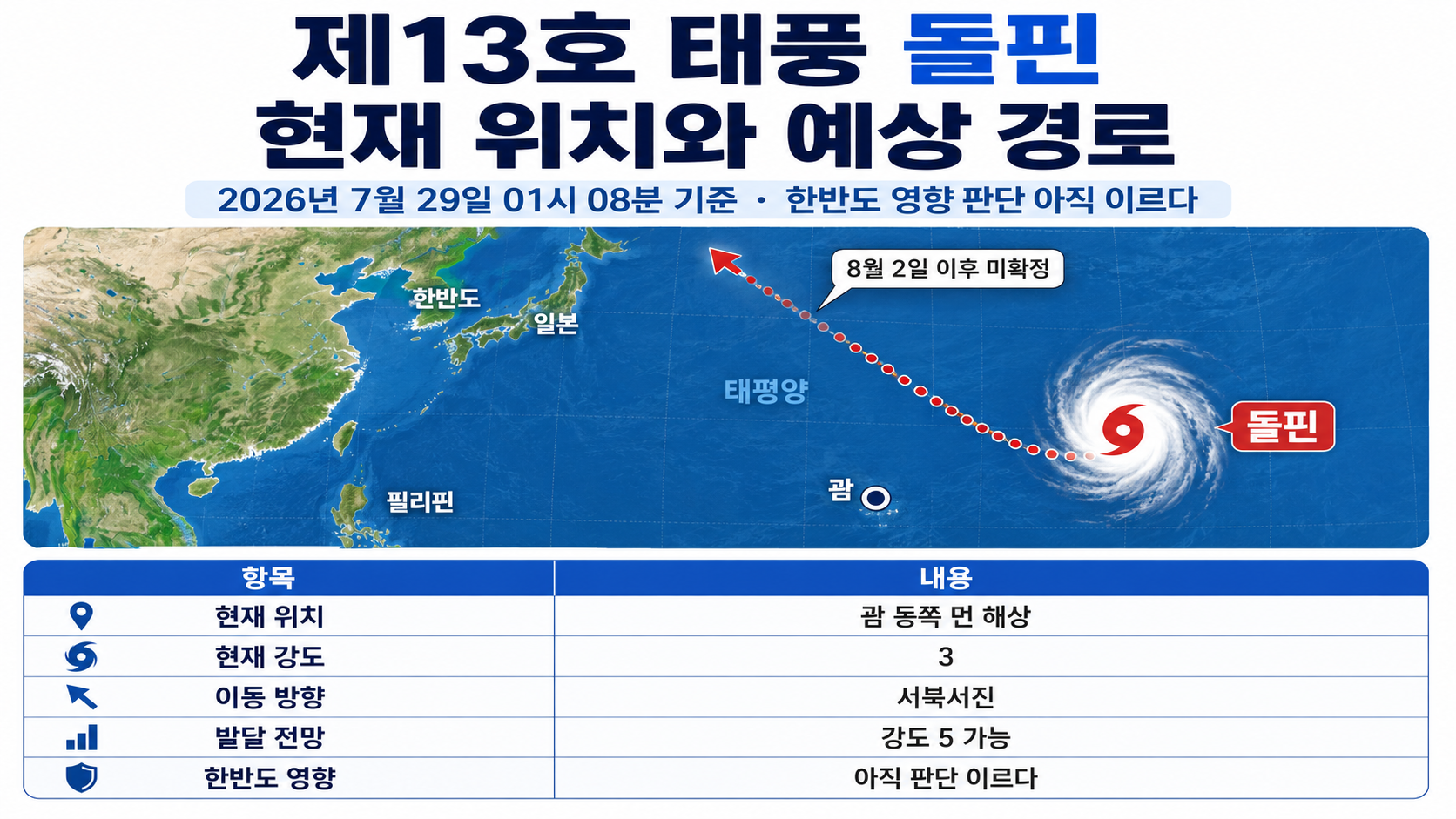
This article is based on the latest reports and official information available as of 2026-07-29 Korea Standard Time.
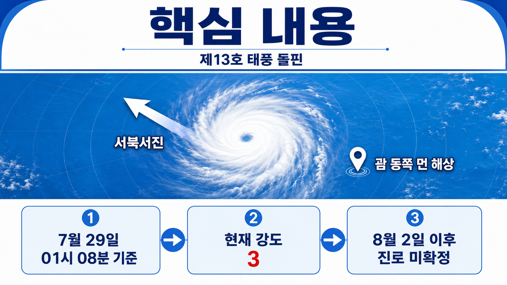
As of 01:08 on 2026-07-29, Typhoon Dolphin No. 13 was moving west-northwest over the open ocean far east of Guam at intensity level 3. The current Korea Meteorological Administration (KMA) forecast does not show the storm entering waters near the Korean Peninsula, but its track beyond August 2 has not yet been determined.
The key distinction is that a forecast predicting the storm will strengthen to intensity level 5 is not the same as a determination that it will affect South Korea.
Where Is Typhoon Dolphin Now?
The latest official information currently available is the typhoon advisory issued by the KMA at 22 on July 28. The analysis time was 21 on 28. At that time, Typhoon Dolphin was moving west-northwest at 14 km/h over waters at latitude 13.4°N and longitude 170.8°E.
| Category | Latest Analyzed Value |
|---|---|
| Analysis time | 2026-07-28 at 21 |
| Center location | 13.4°N, 170.8°E |
| Direction of movement | West-northwest |
| Movement speed | 14 km/h |
| Central pressure | 970 hPa |
| Maximum wind speed | 35 m/s, 126 km/h |
| Typhoon intensity | Level 3 |
| Strong-wind radius | Approximately 290 km |
| Storm-force wind radius | Approximately 70 km |
The storm is located more than approximately 2,800 km east of Guam, far out at sea. Although the typhoon is already powerful, it remains far from the Korean Peninsula. Its current intensity alone is therefore not enough to determine whether it will affect South Korea.
Forecast Track and Intensity Through August 2
Typhoon Dolphin is expected to move west-northwest or northwest for the time being while intensifying rapidly. The KMA forecasts that it could reach intensity level 4 by the night of July 29 and potentially attain the highest intensity level, 5, by the night of July 31.
| Forecast Time | Center Location | Central Pressure | Maximum Wind Speed | Intensity | 70% Probability Radius |
|---|---|---|---|---|---|
| July 28 at 21 (current) | 13.4N, 170.8E | 970 hPa | 35 m/s | 3 | - |
| July 29 at 21 | 14.9N, 167.4E | 945 hPa | 45 m/s | 4 | 80 km |
| July 31 at 21 | 18.7N, 160.2E | 910 hPa | 56 m/s | 5 | 190 km |
| August 1 at 21 | 20.9N, 156.3E | 910 hPa | 56 m/s | 5 | 290 km |
| August 2 at 21 | 23.5N, 152.3E | 915 hPa | 55 m/s | 5 | 440 km |
Over the 72-hour period from 21 on July 28 to 21 on 31, maximum wind speeds are forecast to increase by 21 m/s, from 35 m/s to 56 m/s. According to the author's calculation, this represents an increase of approximately 60%, while central pressure is expected to fall by 60 hPa, from 970 hPa to 910 hPa.
The calculation is as follows:
`(56m/s - 35m/s) ÷ 35m/s × 100 = 60%`
However, the values shown in the table for 29 and later are forecasts, not observed results. The storm's actual rate of intensification and center position may change in subsequent advisories.
Is Typhoon Dolphin Heading Toward South Korea?
The current official forecast track does not provide sufficient grounds to say that Typhoon Dolphin is heading toward South Korea. Even its forecast center position at 21 on August 2 is latitude 23.5°N and longitude 152.3°E. The KMA forecast table does not yet show the storm entering waters near the Korean Peninsula.
Conversely, it is also too early to conclude that the storm will have no impact on South Korea. Its track beyond August 2 has not yet been provided, and uncertainty about the typhoon's center position increases as the forecast period extends further into the future.
The following distinctions are important at this stage:
Confirmed facts: Typhoon Dolphin is moving west-northwest and intensifying.
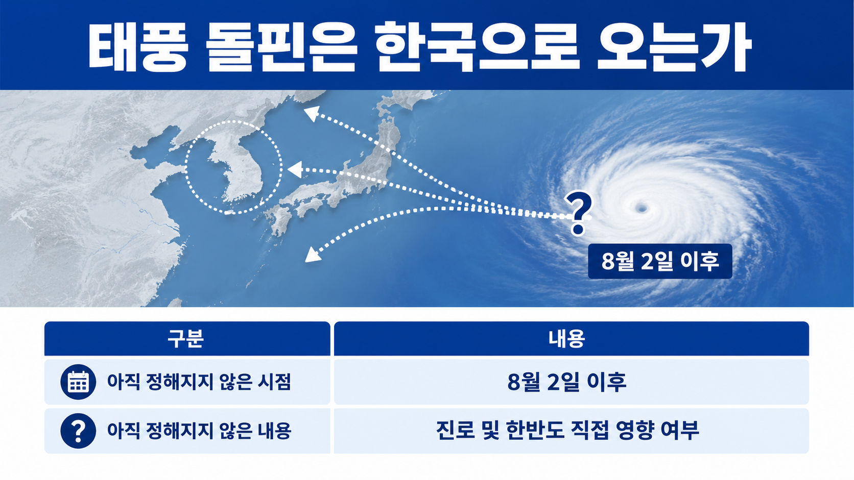
Official forecast: The storm could strengthen to intensity level 5 beginning on July 31.
Still undetermined: Its track beyond August 2 and whether it will directly affect the Korean Peninsula.
Claims to treat with caution: Statements such as 'Landfall in South Korea confirmed,' 'Direct hit on the Korean Peninsula,' and 'No impact expected' all go beyond what the current information supports.
In upcoming forecasts, the priorities are to check how the predicted center position changes, whether the 70% probability radius approaches waters around the Korean Peninsula, and whether marine or land-based weather warnings are issued in South Korea.
How Powerful Is Intensity Level 5?
Under the KMA classification, intensity level 5 refers to a typhoon with maximum sustained winds near its center of at least 54 m/s. Dolphin is forecast to strengthen to 56 m/s on July 31 and August 1, equivalent to approximately 202 km/h.
Since 2026, the KMA has expressed typhoon intensity numerically, using levels from 1 through 5.
| Typhoon Intensity | Maximum Wind Speed Near the Center |
|---|---|
| Level 1 | At least 17 m/s but less than 25 m/s |
| Level 2 | At least 25 m/s but less than 33 m/s |
| Level 3 | At least 33 m/s but less than 44 m/s |
| Level 4 | At least 44 m/s but less than 54 m/s |
| Level 5 | 54 m/s or higher |
Maximum wind speed here refers to the strongest wind observed or forecast near the typhoon's center. It does not mean that every area the typhoon approaches will experience winds of 56 m/s.
The wind and rainfall actually experienced in South Korea depend on factors including distance from the storm's center, the strong-wind radius, terrain, and the direction in which the typhoon is moving.
The 70% Probability Radius Is Not the Size of the Typhoon
The 70% probability radius represents the area within which the typhoon's center is likely to be located at the forecast time. It is different from the strong-wind radius, which indicates the area experiencing strong winds.
Dolphin's 70% probability radius expands from 80 km on the night of July 29 to 440 km on the night of August 2. This is because predicting the storm's exact center position becomes more difficult further into the future.
The central line drawn on a forecast track map is not necessarily the exact path the typhoon will follow. It would be inappropriate to conclude that the storm will make landfall in or pass through a particular area based solely on that line. The surrounding probability area and strong-wind radius must also be considered.
What Should Residents of South Korea Check Now?
At present, the appropriate response is to monitor updated advisories regularly, rather than evacuating or canceling all plans on the assumption that the storm will directly affect South Korea. The next KMA typhoon advisory is expected around 04 on July 29.
If You Have Travel or Outdoor Plans
If you are planning a trip to Guam, Japan, or areas around the northwestern Pacific in early August, check local weather warnings at your destination as well as airline and shipping company announcements, rather than relying solely on the typhoon's forecast track.
A forecast track that remains far away does not necessarily eliminate the possibility of flight cancellations. Likewise, a powerful typhoon does not automatically mean that every flight will be canceled. Actual flight operations depend on wind and rainfall conditions at airports and along flight routes, as well as airline operating plans.
How to Check Your Home and Vehicle
If the possibility of impacts in South Korea increases, or strong-wind or heavy-rain forecasts are issued for your area, inspect the following items in advance.
Move flowerpots, drying racks, signs, and other objects that could be blown away from balconies and rooftops to indoor locations.
Check that drains and sewers around your home are not blocked.
Make a plan to move vehicles parked in flood-prone areas or underground parking garages in low-lying locations to safer places.
Check essential emergency supplies, including phone chargers, flashlights, basic medications, and drinking water.
Review notification settings to ensure you can receive alerts from the Emergency Ready app and local government disaster text messages.
If Typhoon or Heavy Rain Warnings Are Issued
Stay away from riverbanks, valleys, breakwaters, coastal roads, and flooded underpasses. Do not attempt to drive through flooded roads. Residents of landslide-prone areas or low-lying neighborhoods should prioritize evacuation instructions issued by local authorities.
Why Do Some Reports Give Maximum Wind Speeds of 55 m/s While Others Say 56 m/s?
Observed and forecast values are updated whenever new typhoon information is issued. Articles based on the morning announcement on July 28 reported a forecast maximum wind speed of 55 m/s for July 31. However, the KMA advisory issued at 22 on 28 revised that figure to 56 m/s.
When reviewing typhoon-related figures, it is important to check three things together rather than comparing numbers alone.
1. When the article was written
2. When the KMA advisory was issued
3. Whether the figure is a current observation or a future forecast
To check the typhoon's current position, refer to the 'Current' section of the latest KMA advisory. To check its expected future intensity, consult the date-specific 'Forecast' section.
Assessment at This Stage
Typhoon Dolphin No. 13 has intensified to level 3 and could reach intensity level 5 beginning on July 31. However, as of 01:08 on July 29, neither a direct impact on the Korean Peninsula nor a landfall track has been confirmed.
The next steps are to check the KMA advisory at 04 on 29, monitor changes in the forecast center position, and watch for marine and land-based weather warnings in South Korea. Decisions should be based on the latest official information with a clearly stated issuance time, rather than headlines from older articles.
이 포스팅은 쿠팡 파트너스 활동의 일환으로, 이에 따른 일정액의 수수료를 제공받습니다.