

Current Tracks of Typhoon No. 13 Dolphin, No. 14 Kujira, and No. 15 Chan-hom and Their Impact on the Korean Peninsula
Below is the complete article, ready to publish directly on Naver Blog.
Current Tracks of Typhoon No. 13 Dolphin, No. 14 Kujira, and No. 15 Chan-hom and Their Impact on the Korean Peninsula
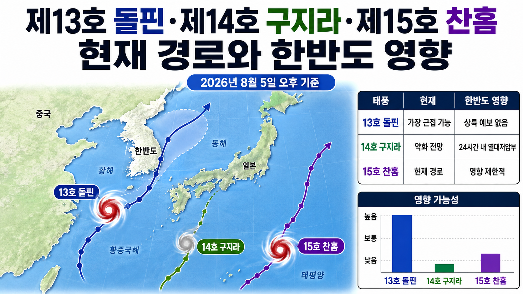
As of the afternoon of 2026-08-05, Typhoon No. 13 Dolphin is the most likely of the three typhoons to approach the Korean Peninsula. However, the Korea Meteorological Administration's current forecast track does not indicate landfall on the Korean Peninsula or Jeju Island entering the strong-wind radius. Kujira is expected to weaken into a tropical depression within 24 hours, while Chan-hom is likely to move northward into the open waters east of Japan.
How Do the Three Typhoons Compare in Their Current Strength?
Typhoon No. 13 Dolphin is a typhoon with an intensity classification of 3 and maximum sustained winds of 43 meters per second, making it considerably stronger than Kujira and Chan-hom. Typhoon No. 14 Kujira and Typhoon No. 15 Chan-hom both have an intensity classification of 1, and Kujira is expected to weaken rapidly.
The following table compares the three typhoons using the same reference criteria from the Korea Meteorological Administration's afternoon advisories issued on August 5.
| Typhoon | Center Position at 15:00 on 5 | Central Pressure | Maximum Wind Speed | Direction and Movement Speed | Current Outlook |
|---|---|---|---|---|---|
| No. 13 Dolphin | 25.7°N, 137.3°E | 950 hPa | 43 m/s · 155 km/h | West-northwest · 17 km/h | Expected to continue moving westward while maintaining intensity 3 |
| No. 14 Kujira | 17.9°N, 118.9°E | 998 hPa | 19 m/s · 68 km/h | North · 15 km/h | Expected to weaken into a tropical depression within 24 hours |
| No. 15 Chan-hom | 19.6°N, 165.8°E | 998 hPa | 18 m/s · 65 km/h | Northeast · 15 km/h | Expected to move northward toward the open waters east of Japan |
According to the author's calculations, Dolphin's maximum wind speed is approximately 2.26 times that of Kujira and approximately 2.39 times that of Chan-hom.
The respective calculations are `43÷19` and `43÷18`. This does not mean that differences in wind speed translate into proportional differences in actual damage. Typhoon damage depends on the storm's track, duration, strong-wind radius, terrain, and rainfall.
Dolphin Is the Typhoon Most Likely to Approach the Korean Peninsula
Of the three typhoons, Dolphin currently deserves the closest attention in South Korea. Dolphin is forecast to move westward toward the East China Sea after passing through waters south of Okinawa, Japan. However, the Korea Meteorological Administration's forecast centerline remains considerably south of Jeju Island.
The forecast center position at 3:00 on August 8 is 27.1°N, 125.2°E. Using approximately 33.4°N, 126.5°E as the center of Jeju Island, a simple straight-line distance calculation gives approximately 710 km.
Dolphin's forecast strong-wind radius at the same time is 400 km. Therefore, if the storm follows the currently forecast centerline, Jeju Island will remain outside the strong-wind radius.
However, the 70% probability radius in the afternoon forecast for August 10 expands to 440 km. As the forecast period extends, the area through which the typhoon's center could actually pass becomes larger. Therefore, the possibility of impacts on South Korea should not be completely ruled out based solely on the current track.
Based on currently available information, it is more accurate to describe the situation as 'limited indications of direct impacts, but continued monitoring of possible track changes is necessary' rather than 'landfall on the Korean Peninsula is expected.'
Kujira Is Expected to Weaken Within 24 Hours
Typhoon No. 14 Kujira is expected to move from the eastern South China Sea toward Luzon Island in the Philippines before weakening into a tropical depression on the afternoon of August 6.
Its forecast maximum wind speed on the afternoon of August 6 is 15 meters per second, falling below the typhoon threshold of 17 meters per second. Considering both its current track and expected weakening, the likelihood of Kujira directly affecting the Korean Peninsula is very low.
Kujira is a name submitted by Japan. Rather than referring simply to the common noun for a whale, it represents Cetus, the whale constellation.
Chan-hom Is Heading Toward the Open Waters East of Japan
Typhoon No. 15 Chan-hom developed into a typhoon on the afternoon of August 5. It formed in the eastern part of the northwestern Pacific, far from the Korean Peninsula, and current forecasts indicate that it will move northward before heading into waters east of Japan.
Its forecast center position on the afternoon of August 10 is 36.5°N, 148.0°E. Although its latitude will become similar to that of central Korea, its longitude places it far offshore to the east of Japan. Therefore, the current forecast track shows no indication of direct impacts on South Korea.
Chan-hom is a name submitted by Laos and refers to a type of tree.
The Forecast Cone Does Not Represent the Size of a Typhoon
On typhoon track maps, a circle that grows larger over time does not mean that the typhoon itself is expanding. The 70% probability radius indicates that the probability of the typhoon's center being within the specified area at a particular time is 70%.
The actual extent of the typhoon's winds must be checked separately using its strong-wind radius and storm-force wind radius.
The strong-wind radius is the area extending from the typhoon's center where winds reach at least 15 meters per second, while the storm-force wind radius is the area where winds reach at least 25 meters per second. Even if the forecast centerline does not pass directly over a particular region, a wide strong-wind radius can still bring strong winds and high waves.
When checking a typhoon's forecast track, it is advisable to look beyond the centerline and review the following information in order.
1. Advisory issuance time
2. Current position and direction of movement
3. Maximum wind speed and central pressure
4. Strong-wind radius and storm-force wind radius
5. 70% probability radius
6. Weather advisories and short-term forecasts for your area
Jeju Island and the Southern Coast Should Also Monitor High Waves and Swells
Whether an area falls within a typhoon's direct impact zone and whether marine conditions deteriorate are separate issues. Forecasts for Jeju indicate that winds and waves in surrounding waters may intensify from the early morning of August 6, with waves of 5 meters or higher possible in the far offshore waters south of Jeju Island.
From the night of August 6, strong swells may also move into coastal areas, potentially washing over rocky shores and breakwaters. Anyone planning to sail, fish, or visit coastal areas should check marine forecasts and high-wave advisories in addition to the typhoon's track.
Even when strong winds from a typhoon are not directly felt on land, waves generated far offshore can still reach the coast.
Next Scheduled Official Advisories
The next scheduled advisory times announced in the afternoon bulletins on August 5 are as follows.
Typhoon No. 13 Dolphin: Around 10:00 p.m. on August 5
Typhoon No. 14 Kujira: Around 10:30 p.m. on August 5
Typhoon No. 15 Chan-hom: Around 11:00 p.m. on August 5
The three typhoons are moving in different directions, and their intensities are also changing rapidly. In particular, it is important to check whether Dolphin's forecast position and 70% probability radius change between August 8 and 10.
According to the currently issued forecasts, Kujira and Chan-hom are unlikely to directly affect South Korea, and Dolphin is also not forecast to make landfall on the Korean Peninsula. However, residents and visitors in Jeju Island and along the southern coast should separately monitor local weather information, including high waves and swells.